Region
Gondor
The last great kingdom of Men in the south, from the White Mountains to the Bay of Belfalas
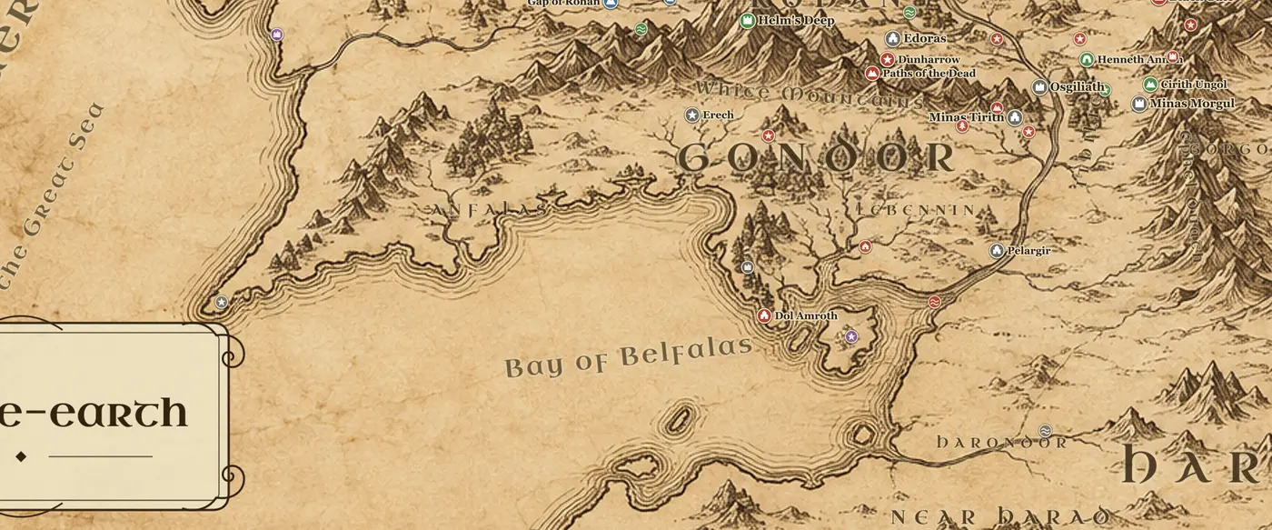
Gondor occupies the southwest of the main Middle-earth map. The White Mountains run through the middle of it from east to west, dividing the northern province of Anorien from the coastal fiefs in the south. To the north lies Rohan, to the east across the Anduin lie Ithilien and then the Ephel Duath and Mordor, and to the south and west the land runs down to the Bay of Belfalas and the sea. The Anduin, now broad and slow, curves past the Emyn Muil, drops over the Falls of Rauros, passes the island of Cair Andros and Osgiliath, and reaches the sea through the delta of the Ethir Anduin.
Minas Tirith, the Tower of Guard, is built in seven walled tiers against a spur of Mount Mindolluin, with the flat Pelennor Fields before it and the ruins of Osgiliath, the old capital, a few miles east on both banks of the river. North of the Pelennor the road to Rohan runs under the Drudan Forest, home of the Woses. South and west, the fiefs stretch out: Lebennin with its five rivers, the port of Pelargir on the Anduin, Linhir on the Gilrain, Lamedon and the Hill of Erech in the mountain valleys, the princedom of Dol Amroth on its cape, and the long shore of Anfalas out toward Andrast.
Gondor was founded by Isildur and Anarion in SA 3320 and was the stronger of the two Numenorean realms in exile. It reached its widest extent under Hyarmendacil I, then lost ground to plague, kin-strife and invasion. The line of kings failed in TA 2050 when Earnur rode to Minas Morgul and never returned, and the Ruling Stewards governed for nearly a thousand years after that. Ithilien was slowly abandoned, and by TA 3018 only rangers under Faramir keep it, working from the hidden refuge of Henneth Annun behind its waterfall.
The last third of The Lord of the Rings happens here. Boromir and later Pippin come to Minas Tirith, Denethor despairs, the Witch-king breaks the city gate, and the Rohirrim arrive at dawn on March 15, TA 3019. Aragorn comes up the Anduin from Pelargir with the ships he has taken, and the Battle of the Pelennor Fields is won. Afterwards the host marches to the Black Gate, and on May 1 Aragorn is crowned King Elessar.
Frequently asked questions
Where is Gondor on the Middle-earth map?
Gondor is the southwestern kingdom, south of Rohan and west of Mordor. It surrounds the White Mountains and runs down the lower Anduin to the Bay of Belfalas.
Where is Minas Tirith on the map?
Minas Tirith stands on the west bank of the Anduin at the eastern end of the White Mountains, built against Mount Mindolluin, with the Pelennor Fields around it and Osgiliath a few miles east.
How far is Minas Tirith from Mordor?
Very close. Osgiliath is a few miles east of the city, and Minas Morgul in the Ephel Duath is only about forty miles beyond that, which is why Ithilien was abandoned.
Who ruled Gondor during The Lord of the Rings?
Denethor II, the twenty-sixth Ruling Steward. Gondor had no king from TA 2050 until Aragorn was crowned King Elessar on May 1, TA 3019.