Region
Mordor
Sauron's walled land in the southeast, ringed by mountains and lit by the fires of Mount Doom
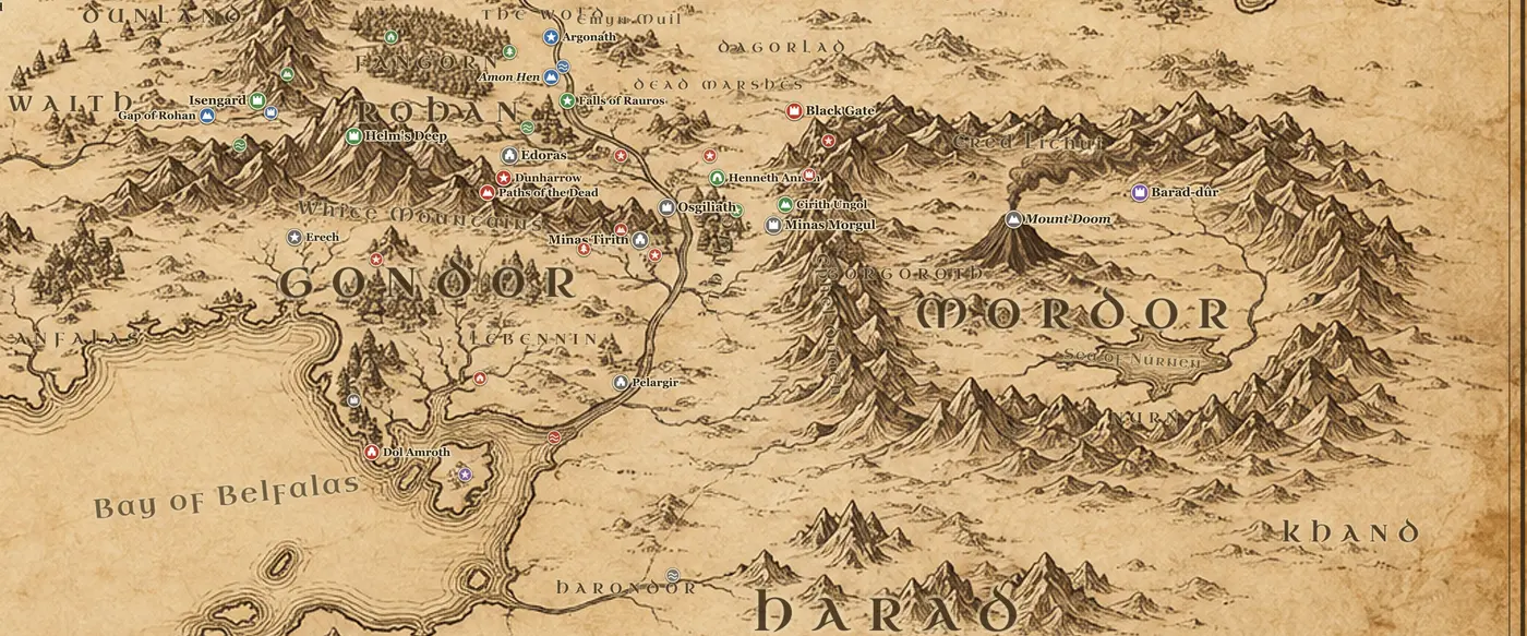
Mordor is the most defensible shape on the Middle-earth map, and Tolkien drew it that way on purpose. Two mountain ranges meet at right angles: the Ephel Duath, the Mountains of Shadow, run north to south along the western side and then turn east across the south, while the Ered Lithui, the Ash Mountains, close the northern border. Where the two ranges almost meet in the northwest corner stands the Morannon, the Black Gate, with the valley of Udun behind it. Outside that corner lie the barren plain of Dagorlad and, further northwest, the Dead Marshes, which have swallowed the battlefield of the Last Alliance.
Inside the fence the land is in two halves. The north is Gorgoroth, a high plateau of ash, slag and fuming pits, with Mount Doom, Orodruin, standing alone in it and the long causeway running east from the mountain to Barad-dur on its spur of the Ered Lithui. The south is Nurn, which is greener, worked by slaves and watered by the inland Sea of Nurnen, and it is the reason Sauron's armies can be fed at all.
There are only a few ways in. The Black Gate is one. The pass of Cirith Ungol above Minas Morgul is another, a stair and a tunnel through the Ephel Duath where the spider Shelob lairs, with the Tower of Cirith Ungol watching the far side. Minas Morgul itself was Gondor's Minas Ithil until the Nazgul took it in TA 2002.
Sauron first settled here around SA 1000 and built Barad-dur with the power of the One Ring. The Last Alliance besieged the tower for seven years and threw him down in SA 3441, when Isildur cut the Ring from his hand. Gondor watched the empty land for centuries, then let the guard slip, and Sauron returned openly in TA 2942 after being driven from Dol Guldur.
The last stretch of Frodo's road runs through here. He and Sam cross the Dead Marshes, are turned back at the Black Gate, come in over the pass of Cirith Ungol instead, and cross Gorgoroth on foot in March TA 3019. The Ring goes into the Cracks of Doom on March 25, Barad-dur falls, and Aragorn afterwards gives Nurn and the Sea of Nurnen to the slaves who worked it.
Frequently asked questions
Where is Mordor on the Middle-earth map?
Mordor is in the southeast, east of the Anduin and Gondor's province of Ithilien. It is the land enclosed by the Ephel Duath on the west and south and the Ered Lithui on the north.
Where is Mount Doom on the map?
Mount Doom, or Orodruin, stands alone on the plateau of Gorgoroth in northwest Mordor, roughly forty miles west of Barad-dur and joined to it by a raised causeway.
How do you get into Mordor?
In the books there are three practical ways: the Black Gate in the northwest corner, the pass of Cirith Ungol above Minas Morgul, and the southern roads from Harad into Nurn.
Is all of Mordor a wasteland?
No. Gorgoroth in the north is ash and slag, but Nurn in the south around the Sea of Nurnen is farmland worked by slaves, and it fed Sauron's armies.