Region
Misty Mountains
The long north-south wall of peaks that splits Middle-earth, pierced by Moria and the High Pass
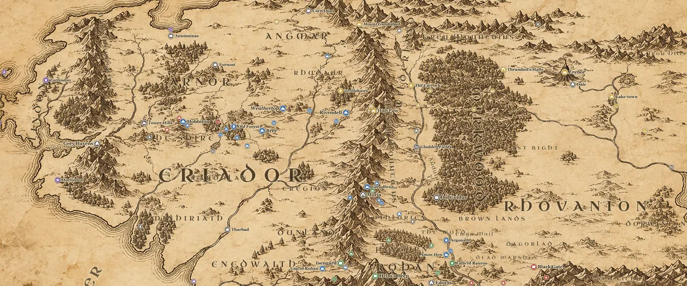
The Misty Mountains are the longest single feature on the Middle-earth map, a wall of stone running almost due north to south for some 900 miles. Mount Gundabad stands at the northern end where the Grey Mountains branch away east, and Methedras closes the range in the south above Isengard and the Gap of Rohan. Everything west of them is Eriador, everything east is the vale of the Anduin, Mirkwood and the wide lands of Rhovanion. The Elves called the range Hithaeglir.
Crossing them is the problem that drives half the plot of both books. In the north the High Pass climbs from the Trollshaws and Rivendell over to the Anduin, and under it lies Goblin-town, where Bilbo is separated from the Dwarves and finds the Ring in Gollum's cave. Roughly 200 miles south, three peaks stand together above the valley of Azanulbizar: Caradhras the Redhorn, Celebdil the Silvertine and Fanuidhol the Cloudyhead. The Redhorn Pass runs between them, and beneath them the Dwarves delved Khazad-dum.
Moria is the heart of the range. Durin's folk mined here from the deeps of time and grew rich on mithril, which is found nowhere else. The Doors of Durin open on the western side toward Eregion, and the eastern gate looks out over the Dimrill Dale to the dark water of Mirrormere. In TA 1980 the Dwarves dug too deep and woke a Balrog, which killed Durin VI and emptied the city. Balin led a colony back in TA 2989 and it was destroyed within five years.
In The Hobbit the company is caught in a thunder-battle on the High Pass, captured by goblins, and carried out by eagles to the Carrock. In The Lord of the Rings the Fellowship tries the Redhorn Pass in January TA 3019, is driven back by snow and by Caradhras itself, and goes through Moria instead. Gandalf falls with the Balrog from the Bridge of Khazad-dum, and their fight ends on the peak of Celebdil, where Gandalf casts down his enemy and dies before returning as Gandalf the White.
On the map, the names to pick out are Gundabad in the far north, the High Pass and Goblin-town above Rivendell, Caradhras, Celebdil and Fanuidhol in the middle, with Moria, the Doors of Durin, the Dimrill Dale and Mirrormere around them, and Methedras at the southern tip.
Frequently asked questions
Where are the Misty Mountains on the Middle-earth map?
They run down the center of the northern map, from Mount Gundabad in the north to Methedras above the Gap of Rohan in the south, separating Eriador from the Anduin valley and Rhovanion.
How do you cross the Misty Mountains?
There are three routes in the books: the High Pass east of Rivendell, the Redhorn Pass under Caradhras, and the tunnels of Moria beneath the mountains. Otherwise travelers go around by the Gap of Rohan in the south.
Where is Moria on the map?
Moria lies under the three peaks of Caradhras, Celebdil and Fanuidhol, about halfway down the range. Its west door faces Eregion and its east gate opens on the Dimrill Dale above Lothlorien.
How long are the Misty Mountains?
About 900 miles from Mount Gundabad to Methedras, which makes them the longest mountain range shown on the standard Middle-earth map.