Region
Lindon
The last Elvish coastland west of the Blue Mountains, where ships leave Middle-earth from the Grey Havens
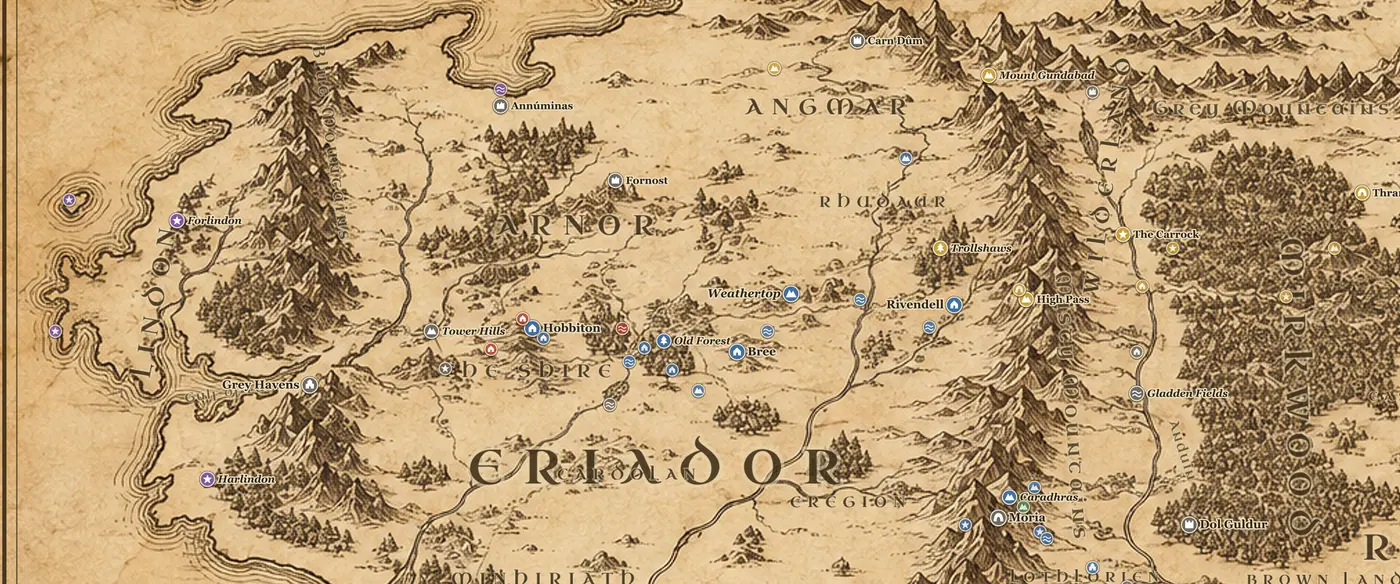
Lindon occupies the far western edge of the Middle-earth map, west of the Blue Mountains and facing the ocean called Belegaer. The Gulf of Lune cuts deep into the coast and divides the land into two arms: Forlindon to the north of the gulf and Harlindon to the south. The River Lune runs down out of Eriador into the gulf, and at its head stand the Grey Havens, Mithlond, the harbor from which the White Ships sail west. Inland, the Tower Hills and their three white towers mark the boundary between Lindon and the lands of the Shire.
What survives here is a remnant of a drowned world. In the First Age this coast was the eastern march of Beleriand, and when Beleriand was broken at the end of that Age the sea took almost everything west of the Blue Mountains. Only high ground remained above the water, which is why the map shows the islands of Himling, Tol Fuin and Tol Morwen offshore. Himling was once the hill of Himring where Maedhros held his fortress, and Tol Morwen holds the standing stone raised over the graves of Turin's family.
Through the Second Age Lindon was the great Elvish kingdom of Middle-earth under Gil-galad, the last High King of the Noldor. From here he resisted Sauron, received Numenorean fleets, and in SA 3430 joined Elendil in the Last Alliance. Gil-galad fell before Barad-dur in SA 3441, and after him Lindon dwindled to Cirdan's havens and a scattering of Elvish settlements that slowly emptied as their people took ship.
In The Lord of the Rings Lindon is mostly a destination rather than a stage. Cirdan gave Narya, the Ring of Fire, to Gandalf when he first landed at the Havens, and Gandalf, Elrond and Galadriel pass back through the Grey Havens at the very end of the story. Frodo and Bilbo sail from there in TA 3021, with Sam, Merry and Pippin watching from the quay, and Sam himself is said to follow years later.
On the map, look for the Grey Havens at the head of the Gulf of Lune, Forlindon and Harlindon on either side, the Blue Mountains along the inland border, and the Tower Hills between Lindon and the Shire.
Frequently asked questions
Where is Lindon on the Middle-earth map?
Lindon is the coastal strip on the far west edge of the map, between the Blue Mountains and the Great Sea. The Gulf of Lune splits it into Forlindon in the north and Harlindon in the south.
Where are the Grey Havens?
The Grey Havens, or Mithlond, stand at the head of the Gulf of Lune where the River Lune meets the sea, roughly a hundred miles west of the Shire along the Great East Road.
Why is Lindon so narrow on the map?
Lindon is what is left of Beleriand after the War of Wrath sank most of that land at the end of the First Age. The islands of Himling, Tol Fuin and Tol Morwen offshore are the peaks of drowned hills.